Becsehely | |
|---|---|
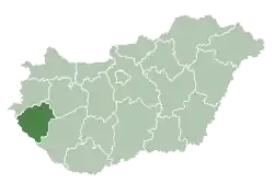
 Becsehely Location of Becsehely | |
| Coordinates: 46°26′45″N 16°47′14″E / 46.44595°N 16.78713°E | |
| Country | |
| County | Zala |
| Area | |
| • Total | 36.13 km2 (13.95 sq mi) |
| Population (2004) | |
| • Total | 2,279 |
| • Density | 63.07/km2 (163.4/sq mi) |
| Time zone | UTC+1 (CET) |
| • Summer (DST) | UTC+2 (CEST) |
| Postal code | 8866 |
| Area code | 93 |
| Motorways | M7 |
| Distance from Budapest | 227 km (141 mi) Northeast |
Becsehely (Croatian: Bečehel) is a village in Zala County, Hungary.
External links
- Street map (in Hungarian)
.svg.png.webp)
This article is issued from Wikipedia. The text is licensed under Creative Commons - Attribution - Sharealike. Additional terms may apply for the media files.