Balutungi | |
|---|---|
Village | |
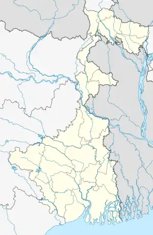 Balutungi Location in West Bengal, India | |
| Coordinates: 24°22′54″N 88°16′36″E / 24.3817°N 88.2767°E | |
| Country | |
| State | West Bengal |
| District | Murshidabad |
| Government | |
| • Type | Panchayat |
| Languages | |
| • Official | Bengali, English |
| Time zone | UTC+5:30 (IST) |
| Lok Sabha constituency | Jangipur |
| Vidhan Sabha constituency | Lalgola |
| Website | murshidabad |
Balutungi is a village in Lalgola CD Block in Lalbag subdivision of Murshidabad district in West Bengal.
Geography
Balutungi is bordered by four villages: in the east by Airmari, in the west by Fudhkipara and Basupara, in the north by Madhupur, and in the south by Dhulauri.
Neighbourhoods
Balutugi is divided in 3 major divisions.
- Bhatupara (at the very south)
- Siropara (at the very north)
- Majhpara (at the middle)
There are also 2 minor divisions:
- Hindu para (at the north-east side)
- Kamarpara (at the north)
The Hindus live at Hindu para.
Transport
SH 11A, running from Bhagawangola to Raghunathganj passes through Balutungi.[1]
Education
Balutungi High School was established in 1951.[2]
Balutungi Junior Girls' High School was established in 1968.
References
- ↑ "List of State Highways in West Bengal". West Bengal Traffic Police. Retrieved 4 August 2017.
- ↑ "Balutugi High School Lalgola". SchoolsWorld.in. Retrieved 3 September 2017.
This article is issued from Wikipedia. The text is licensed under Creative Commons - Attribution - Sharealike. Additional terms may apply for the media files.