Armenio
Αρμένιο | |
|---|---|
 Armenio Location within the regional unit 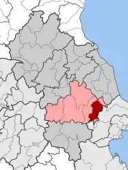 | |
| Coordinates: 39°29′N 22°42′E / 39.483°N 22.700°E | |
| Country | Greece |
| Administrative region | Thessaly |
| Regional unit | Larissa |
| Municipality | Kileler |
| • Municipal unit | 99.403 km2 (38.380 sq mi) |
| Elevation | 58 m (190 ft) |
| Population (2011)[1] | |
| • Municipal unit | 2,096 |
| • Municipal unit density | 21/km2 (55/sq mi) |
| Community | |
| • Population | 756 (2011) |
| • Area (km2) | 23.329 |
| Time zone | UTC+2 (EET) |
| • Summer (DST) | UTC+3 (EEST) |
| Vehicle registration | ΡΙ |
Armenio (Greek: Αρμένιο) is a village and a former municipality in the Larissa regional unit, Thessaly, Greece. Since the 2011 local government reform it is part of the municipality Kileler, of which it is a municipal unit.[2] Population 2,096 (2011). The municipal unit has an area of 99.403 km2.[3]
References
- 1 2 "Απογραφή Πληθυσμού - Κατοικιών 2011. ΜΟΝΙΜΟΣ Πληθυσμός" (in Greek). Hellenic Statistical Authority.
- ↑ "ΦΕΚ B 1292/2010, Kallikratis reform municipalities" (in Greek). Government Gazette.
- ↑ "Population & housing census 2001 (incl. area and average elevation)" (PDF) (in Greek). National Statistical Service of Greece. Archived (PDF) from the original on 2015-09-21.
This article is issued from Wikipedia. The text is licensed under Creative Commons - Attribution - Sharealike. Additional terms may apply for the media files.