Ano Fanari
Άνω Φανάρι | |
|---|---|
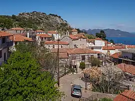 View of the village | |
 Ano Fanari | |
| Coordinates: 37°34.3′N 23°13.3′E / 37.5717°N 23.2217°E | |
| Country | Greece |
| Administrative region | Attica |
| Regional unit | Islands |
| Municipality | Troizinia-Methana |
| Municipal unit | Troizina |
| Population (2011)[1] | |
| • Rural | 128 |
| Community | |
| • Population | 287 (2011) |
| Time zone | UTC+2 (EET) |
| • Summer (DST) | UTC+3 (EEST) |
| Postal code | 180 80 |
| Area code(s) | 22980 |
Ano Fanari (Greek: Άνω Φανάρι) is a mountain village belonging to the Troizinia-Methana municipality in northeastern Peloponnese, Greece. A small acropolis rises above Ano Fanari. It is situated on the old road from Galatas to Agia Eleni and Epidavros.
Historical population
| Year | Population |
|---|---|
| 1981 | 391 |
| 1991 | 182 |
| 2001 | 160 |
| 2011 | 128 |
See also
- List of settlements in Attica, including the Troizina area
References
- 1 2 "Απογραφή Πληθυσμού - Κατοικιών 2011. ΜΟΝΙΜΟΣ Πληθυσμός" (in Greek). Hellenic Statistical Authority.
External links
This article is issued from Wikipedia. The text is licensed under Creative Commons - Attribution - Sharealike. Additional terms may apply for the media files.