Andornay | |
|---|---|
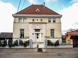 The town hall in Andornay | |
.svg.png.webp) Coat of arms | |
Location of Andornay | |
 Andornay 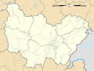 Andornay | |
| Coordinates: 47°39′23″N 6°35′51″E / 47.6564°N 6.5975°E | |
| Country | France |
| Region | Bourgogne-Franche-Comté |
| Department | Haute-Saône |
| Arrondissement | Lure |
| Canton | Lure-2 |
| Intercommunality | Pays de Lure |
| Government | |
| • Mayor (2020–2026) | Denis Ledoux[1] |
| Area 1 | 1.48 km2 (0.57 sq mi) |
| Population | 183 |
| • Density | 120/km2 (320/sq mi) |
| Time zone | UTC+01:00 (CET) |
| • Summer (DST) | UTC+02:00 (CEST) |
| INSEE/Postal code | 70021 /70200 |
| Elevation | 299–329 m (981–1,079 ft) |
| 1 French Land Register data, which excludes lakes, ponds, glaciers > 1 km2 (0.386 sq mi or 247 acres) and river estuaries. | |
Andornay (French pronunciation: [ɑ̃dɔʁnɛ]) is a commune in the Haute-Saône department in the region of Bourgogne-Franche-Comté in eastern France.
Geography
Andornay is located in the north-east of the Bourgogne-Franche-Comté region, in the Haute-Saône département, not far from the Territoire de Belfort and the Doubs.[3]
The small village of Andornay covers just 148 hectares, only one of which is forested.
See also
References
- ↑ "Répertoire national des élus: les maires" (in French). data.gouv.fr, Plateforme ouverte des données publiques françaises. 13 September 2022.
- ↑ "Populations légales 2021". The National Institute of Statistics and Economic Studies. 28 December 2023.
- ↑ 47°36′46″N 6°37′46″E / 47.6128°N 6.6294°E
Wikimedia Commons has media related to Andornay.
This article is issued from Wikipedia. The text is licensed under Creative Commons - Attribution - Sharealike. Additional terms may apply for the media files.