Ambohitompoina | |
|---|---|
 Ambohitompoina Location in Madagascar | |
| Coordinates: 19°45′S 47°34′E / 19.750°S 47.567°E | |
| Country | |
| Region | Vakinankaratra |
| District | Antanifotsy |
| Area | |
| • Total | 422 km2 (163 sq mi) |
| Elevation | 1,606 m (5,269 ft) |
| Population (2018)[3] | |
| • Total | 27,899 |
| Time zone | UTC3 (EAT) |
| Postal code | 113 |
Ambohitompoina is a town and commune in Madagascar. It belongs to the district of Antanifotsy, which is a part of Vakinankaratra Region. The population of the commune was 27,899 in 2018.
Primary and junior level secondary education are available in town. The majority 99% of the population of the commune are farmers. The most important crop is rice, while other important products are beans, maize and cassava. Services provide employment for 1% of the population.[4]
Sights
The town is an entrance place of the Marolambo National Park.[5]
References
- ↑ Aménagement hydroélectrique de Sahofika
- ↑ Estimated based on DEM data from Shuttle Radar Topography Mission
- ↑ TROISIEME RECENSEMENT GENERAL DE LA POPULATION ET DE L’HABITATION
- ↑ "ILO census data". Cornell University. 2002. Retrieved 2008-04-22.
- ↑ Marolambo National Park
Capital: Antsirabe | ||
| Ambatolampy (19) | 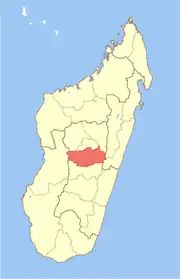 | |
| Antanifotsy (14) | ||
| Antsirabe I (1) | ||
| Antsirabe II (20) | ||
| Betafo (18) | ||
| Faratsiho (9) | ||
| Mandoto (9) | ||
7 districts; 89 communes | ||
19°45′S 47°34′E / 19.750°S 47.567°E
This article is issued from Wikipedia. The text is licensed under Creative Commons - Attribution - Sharealike. Additional terms may apply for the media files.