Aberarder
| |
|---|---|
 | |
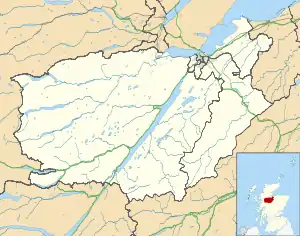 Aberarder Location within the Inverness area | |
| OS grid reference | NN486871 |
| Council area | |
| Country | Scotland |
| Sovereign state | United Kingdom |
| Postcode district | PH20 1 |
| Police | Scotland |
| Fire | Scottish |
| Ambulance | Scottish |
| UK Parliament | |
| Scottish Parliament | |
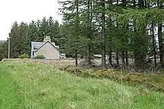
Aberarder (Scottish Gaelic: Obar Àrdair) is a hamlet to the south of Loch Ruthven, Scottish Highlands and is in the Scottish[1] council area of Highland. It lies on the B851 road, to the east of Loch Ness. After the Rising of 1745, Aberarder was owned by the Farquharsons of Invercauld.[2]
References
![]() Media related to Aberarder at Wikimedia Commons
Media related to Aberarder at Wikimedia Commons
- ↑ Microsoft; Nokia (26 February 2017). "Aberarder" (Map). Bing Maps. Microsoft. Retrieved 26 February 2017.
- ↑ Amy Stewart Fraser (1977). In memory long. Routledge. p. 51. ISBN 0-7100-8586-9.
This article is issued from Wikipedia. The text is licensed under Creative Commons - Attribution - Sharealike. Additional terms may apply for the media files.