 | ||||
|---|---|---|---|---|
 | ||||
| Route information | ||||
| Length | 50.7 mi[1] (81.6 km) | |||
| Major junctions | ||||
| East end | ||||
| West end | ||||
| Location | ||||
| Country | United Kingdom | |||
| Primary destinations | Elgin, Banff, Fraserburgh | |||
| Road network | ||||
| ||||
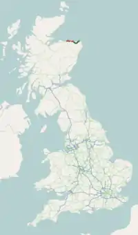
The A98 road is a major coastal road of northeast Scotland passing through Moray and Aberdeenshire. The A98 is no longer a primary route, with this status being removed shortly after the A92 was renumbered A90.
Route

A98 near Craigmaud
It originates in the west at Fochabers at a junction with the A96, and proceeds northeast, passing close to Buckie, Findochty and Portknockie before passing through Cullen and Portsoy.
After a junction with the A95 it passes through Banff and Macduff. It then bears southeast and inland for some distance, passing near to the prehistoric monument of Longman Hill; thence it runs close to New Pitsligo before heading northeast to Fraserburgh where it terminates.
References
- ↑ "Driving directions to A98". Google Maps. Retrieved 21 September 2013.
External links
 Media related to A98 road (Scotland) at Wikimedia Commons
A roads in Zone 9 of the Great Britain road numbering scheme | ||
|---|---|---|
57°40′00″N 2°28′30″W / 57.66666°N 2.47497°W
This article is issued from Wikipedia. The text is licensed under Creative Commons - Attribution - Sharealike. Additional terms may apply for the media files.