Please first note that the flow, while indeed driven by the temperature differences between the tropics and the higher latitude on the global scale, is actually mostly along the isobars in mid-latitudes, not across them. That means that the flow is not from a place of higher pressure to a place of lower pressure, but mostly around the pressure lows and highs. This is because on the large scales the relevant forces are the pressure force and the Coriolis force. That leads to the geostrophic equilibrium. In the planetary boundary layer (lowest ~2 km), the flow is turned in a certain direction towards the low pressure, because the turbulent friction force plays an important role as well. But not above the boundary layer.
Wind gusts are caused by turbulence, chaotic unpredictable movement of fluid that causes strong mixing and friction. In a comment you asked "Why is turbulence related to gust, gust is not chaotic, it has same direction as wind, just speed is increased?" The gust is very local, when looking from a distance, it can be large turbulent structure, but a turbulent structure nonetheless. The largest turbulent vortexes in the turbulent atmospheric flows are sized ~km. They contain the most of the energy. Due to the chaotic nature of turbulence, they give birth to sudden increases in wind speed in various parts of the flow region.
Turbulence develops due to instabilities in the flow typically caused by differences of the wind vector from place to place (wind shear) or differences of density/temperature - often the warm surface of the Earth vs. colder (but it is more complicated due to compressibility).
So even when there are no temperature/density effects (neutral stratification), there will be turbulence due to the wind shear. If there is wind, there is always wind shear, because the wind speed at the surface is zero. If the Reynolds number is high enough, and in the atmosphere it always is, there will be turbulence caused by differences of the flow speed from place to place. When we also account for the stabilizing effect of a stable temperature stratification, the instability is the Kelvin-Helmholtz (K-H) instability that causes turbulence if the wind shear is large enough when compared to the stratification (the ratio is the Richardson number).
See this laboratory demonstration of the K-H instability The same instability creates all ordinary turbulence when any object moves in the air. The turbulence around us, around cars, around aeroplanes.
Turbulence can also be caused by thermal convection even if there is no mean horizontal wind at all. Thermal convection develops when thermal stratification becomes unstable due to positive heat flux from the warm surface. Unfortunately, in a compressible fluid (like the air) the situation is complicated by the compressibility and one must look at the profiles of the potential temperature and not temperature. In a well-mixed atmosphere the potential temperature is constant, but the temperature decreases by one degree of Celsius by every 100 m of height. The result of convection are rising thermals and plumes of warm air in which birds and glider aircraft like to soar. Wind gusts may be well caused by the thermally-produced turbulence.
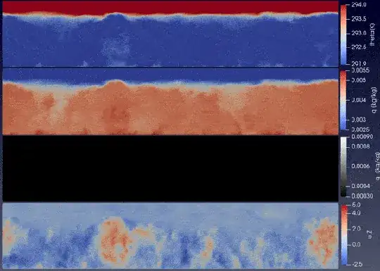 This shows my simulation of thermal convection in the atmosphere with shallow clouds. No mean wind, just thermal turbulence. Potential temperature, moisture, liquid water, vertical velocity.
When thermal convection becomes very strong due to very unstable stratification, storms may develop. Those have their own complicated wind flow, which is very turbulent, and can cause strong gusts. The origin is from the thermal convection, just complicated by the complicated thermodynamics of water in the clouds.
Also, the large scale flow, mentioned at the start of the answer, often creates fronts between warmer and colder air. On these fronts, weather patterns develop on larger scales and especially cold fronts cause locally unstable stratification and hence convection and storms and hence wind gusts.


