I have files in .kml format. In windows 7 I opened them with Google Earth, but Google earth for Linux wrongly determines the place of workout on map.
What application can I use to work with these files?
I have files in .kml format. In windows 7 I opened them with Google Earth, but Google earth for Linux wrongly determines the place of workout on map.
What application can I use to work with these files?
You can view them online with GPS Visualizer. You load them directly with Viking GPS Analyser.
You can also convert them to GPX files using Viking or GPSBabel. Both are available from the Ubuntu repos. See Viking GPS Documentation for details.
GPSPrune claims to support KML for read, view, edit and saving. It is java application and available for linux:
GpsPrune is a free, open source, cross-platform program to view and edit coordinate data like GPS tracks.
Viewing data with a map view using OSM maps
Editing data (delete individual points or sections, variable compression, combine and rearrange data, create and edit individual points)
GpsPrune can read files in the following formats: kml, including zipped and gzipped kml files and kmz files
GpsPrune can also save data to files in the following formats: kml and kmz files (kmz files can include photo thumbnails)
If you're having problems with Google Earth in Ubuntu then you could try using Google Maps to view your .kml files.
As detailed on one of the Official Google blogs:
To view a KML or KMZ file on Maps, just go to Google Maps, and instead of searching for a geographical address like 1600 Amphitheatre Parkway, 94043, search for a complete Web address (including the "http://" part) of your KMZ file, like http://kml.lover.googlepages.com/cropcircles.kmz. Need your own web space to upload some files? Try Google Page Creator.
Google Page Creator has been shut down and Google now encourages to use Google Sites instead.
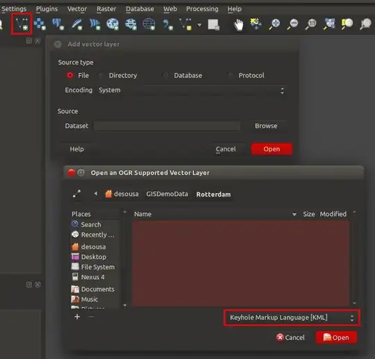
Any software reliant on GDAL for data input should be able to import KML files. On Ubuntu the most recommendable option is QGIS, that supports KML seamlessly. Using the Add Vector Layer dialogue you can import directly a KML file for visualisation and analysis.
I also suggest to use a free conversion tool, like this one: kml2gpx.com to convert them into gpx files. It is a simple and convenient way to get the results you need.
KMZView has been the best free KML/KMZ viewer for our data and app integrations. It is like Google Earth but in your web browser. You can create link for free to share the file too, and add password.
I've been using KMZMap.com for visualizing KML/KMZ files for a while. It's free and they do not store any kml/kmz data. Everything works on the client side.