Native name: Θύμαινα | |
|---|---|
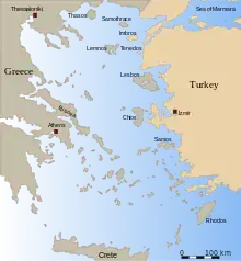
.jpg.webp) The island as seen from Fourni Korseon | |
 Thymaina | |
| Geography | |
| Coordinates | 37°35′N 26°26′E / 37.58°N 26.44°E |
| Archipelago | North Aegean |
| Area | 10 km2 (3.9 sq mi) |
| Highest elevation | 26 m (85 ft) |
| Administration | |
Greece | |
| Region | North Aegean |
| Regional unit | Ikaria |
| Capital city | Thymaina |
| Demographics | |
| Population | 143 (2011) |
| Pop. density | 14/km2 (36/sq mi) |
| Additional information | |
| Postal code | 833 xx |
| Area code(s) | 22750 |
| Vehicle registration | MO |
Thymaina (Greek: Θύμαινα) is a small Greek island in the Ikaria regional unit, in the eastern Aegean Sea. Thymaina is located just west of Fournoi Korseon and is administratively a part of its municipality. Its name is said to be derived from the thyme that grows throughout the island.[1] Thymaina has two settlements, Thymaina settlement and Keramidou. The population of the island is 143 inhabitants according to 2011 census, 136 in Thymaina settlement and 7 in Keramidou[2] and the area is 10 square kilometres (4 sq mi). Thymaina is a protected area along with all Fournoi cluster and belongs to the network Natura 2000.[1]
Historical population
| Census | Island |
|---|---|
| 1991 | 156 (Thymaina 147, Keramidou 9) |
| 2001 | 152 (Thymaina 140, Keramidou 12) |
| 2011 | 143 (Thymaina 136, Keramidou 7) |
References
- 1 2 "Θύμαινα". egeonet.gr. Retrieved 13 July 2016.
- ↑ "Απογραφή Πληθυσμού - Κατοικιών 2011. ΜΟΝΙΜΟΣ Πληθυσμός" (in Greek). Hellenic Statistical Authority.
This article is issued from Wikipedia. The text is licensed under Creative Commons - Attribution - Sharealike. Additional terms may apply for the media files.