Sanguie | |
|---|---|
Province | |
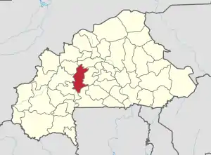 Location in Burkina Faso | |
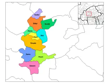 Provincial map of its departments | |
| Coordinates: 12°19′N 2°28′E / 12.317°N 2.467°E | |
| Country | |
| Region | Centre-Ouest Region |
| Capital | Réo |
| Area | |
| • Province | 5,183 km2 (2,001 sq mi) |
| Population (2019 census)[1] | |
| • Province | 391,520 |
| • Density | 76/km2 (200/sq mi) |
| • Urban | 33,894 |
| Time zone | UTC+0 (GMT 0) |
Sanguié is one of the 45 provinces of Burkina Faso, located in its Centre-Ouest Region. In 2019 the population was 391,520.[1] Its capital is Réo.
Lyele is a major first language in this province.
Education
In 2011 the province had 218 primary schools and 27 secondary schools.[2]
Healthcare
In 2011 the province had 34 health and social promotion centers (Centres de santé et de promotion sociale), 3 doctors and 66 nurses.[3]
Transportation
As of June 2014 Sitarail operates a passenger train three times a week along the route from Ouagadougou to Abidjan which passes through the province and stops at Zamo.[4]
Departments
Sanguie is divided into 10 departments:
| Department | Capital | Population (Census 2006)[5] |
|---|---|---|
| Dassa Department | Dassa | 14,782 |
| Didyr Department | Didyr | 41,604 |
| Godyr Department | Godyr | 19,379 |
| Kyon Department | Kyon | 18,124 |
| Kordie Department | Kordie | 20,400 |
| Pouni Department | Pouni | 38,666 |
| Réo Department | Réo | 59, 799 |
| Tenado Department | Tenado | 46,203 |
| Zamo Department | Zamo | 16,242 |
| Zawara Department | Zawara | 21,869 |
See also
References
- 1 2 Citypopulation.de Population of provinces in Centre-Ouest Region
- ↑ "La région du Centre-Ouest en chiffres" (PDF). Institut National de la Statistique et de la Démographie (INSD). 2011. p. 6. Archived from the original (PDF) on 2012-11-13.
- ↑ "La région du Centre-Ouest en chiffres" (PDF). Institut National de la Statistique et de la Démographie (INSD). 2011. p. 6. Archived from the original (PDF) on 2012-11-13.
- ↑ European Rail Timetable, Summer 2014 Edition, (journey time is 43 to 48 hours)
- ↑ National 2006 census preliminary results
12°19′N 2°28′W / 12.317°N 2.467°W
This article is issued from Wikipedia. The text is licensed under Creative Commons - Attribution - Sharealike. Additional terms may apply for the media files.