Salla | |
|---|---|
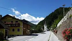 Street in Salla | |
 Coat of arms | |
 Salla Location within Austria | |
| Coordinates: 47°06′30″N 14°58′23″E / 47.10833°N 14.97306°E | |
| Country | Austria |
| State | Styria |
| District | Voitsberg |
| Government | |
| • Mayor | Johann Haller (FPÖ) |
| Area | |
| • Total | 49.42 km2 (19.08 sq mi) |
| Population (1 January 2016)[1] | |
| • Total | 283 |
| • Density | 5.7/km2 (15/sq mi) |
| Time zone | UTC+1 (CET) |
| • Summer (DST) | UTC+2 (CEST) |
| Postal code | 8592 |
| Area code | 03147 |
| Vehicle registration | VO |
| Website | www.salla.steiermark.at |
Salla is a former municipality in the district of Voitsberg in the Austrian state of Styria. Since the 2015 Styria municipal structural reform, it is part of the municipality Maria Lankowitz.[2]
Population
Salla lies west of Graz on the highway between Köflach and Gaberl.
References
This article is issued from Wikipedia. The text is licensed under Creative Commons - Attribution - Sharealike. Additional terms may apply for the media files.