| Råån Råå-ån, Kvistoftaån, Kvistofta-Råån | |
|---|---|
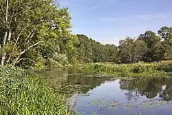 Råån near Råå | |
 Map of Råån's drainage basin. | |
| Location | |
| Country | Sweden |
| County | Skåne |
| District | Svalöv, Helsingborg |
| City | Helsingborg |
| Physical characteristics | |
| Source | Duveke |
| • location | Svalöv Municipality |
| • elevation | 70 m (230 ft) |
| Mouth | Öresund |
• location | Råå, Helsingborg Municipality |
• coordinates | 55°59′30″N 12°44′35″E / 55.99167°N 12.74306°E |
• elevation | 0 m (0 ft) |
| Length | 30 km (19 mi) |
| Basin size | 192.8 km2 (74.4 sq mi)[1] |
| Basin features | |
| Tributaries | |
| • right | Tjutebäcken, Lussebäcken |
References
- ↑ "Län och huvudavrinningsområden i Sverige" (PDF) (in Swedish). Swedish Meteorological and Hydrological Institute. Retrieved 15 July 2010.
This article is issued from Wikipedia. The text is licensed under Creative Commons - Attribution - Sharealike. Additional terms may apply for the media files.