Ravenswood Bridge | |
|---|---|
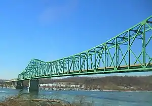 View of the bridge from Ravenswood | |
| Coordinates | 38°56′N 81°46′W / 38.94°N 81.76°W |
| Carries | |
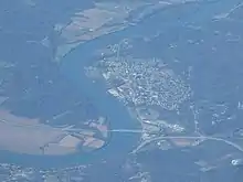
| Crosses | Ohio River |
| Official name | William S. Ritchie, Jr. Bridge[1] |
| Maintained by | West Virginia Department of Transportation[1] |
| Characteristics | |
| Design | Cantilever bridge |
| Total length | 2,710 feet (830 m) |
| Longest span | 900 feet (270 m) |
| History | |
| Opened | 1981 |
| Location | |
State Route 824 | |
|---|---|
| Location | Meigs County |
| Existed | 1981–2003 |
| Location | Ravenswood |
|---|---|
| Existed | 1981–2003 |
The William S. Ritchie Jr. Bridge,[1] more commonly known as the Ravenswood Bridge, is a two-lane cantilever bridge in the United States, connecting Ravenswood, West Virginia and rural Meigs County, Ohio, across the Ohio River. It has a total length of 2,710 ft (830 m) with a main span of 900 ft (270 m). The bridge was completed in 1981.[2]
The bridge replaced a ferry that had crossed the river between Ravenswood at Walnut Street and rural Lebanon Township since at least 1908.[3][4] When the bridge opened in 1981, on the Ohio side of the river, the bridge and its approach route carried the 0.57-mile-long (0.92 km) Ohio State Route 824 (SR 824).[5] The crossing originally led to a winding two-lane SR 338. On the West Virginia side, the bridge carried West Virginia Route 338.[6][1] In 2003, the SR 824 and WV 338 designations were removed when the US 33 relocation in Meigs County was completed and the US 33 designation was moved onto the bridge.[7]
| Browse numbered routes | ||||
|---|---|---|---|---|
| ← | OH | → | ||
| ← | WV | → | ||
See also
References
- 1 2 3 4 "Notice to Contractors - November 30, 1999 Letting". West Virginia Department of Transportation. Retrieved August 13, 2017.
- ↑ The World Almanac and Book of Facts. World Almanac Education Group. 2002. p. 609. ISBN 0-88687-872-1.
- ↑ Ravenswood Quadrangle–West Virginia/Ohio (Topographic map). 1:62,500. 15 Minute Series. United States Geological Survey. 1908. Retrieved November 12, 2016.
- ↑ Map of Ohio Showing State Routes (MrSID) (Map). Cartography by G.F. Schlesinger, Director. Ohio Division of Highways. 1925. Retrieved August 18, 2013.
- ↑ "2001 MEIGS CO 2 AVERAGE 24-HR TRAFFIC VOLUME" (PDF). ODOT. 2001. p. 3. Retrieved January 20, 2014.
- ↑ "Design Guide For Signing" (PDF). West Virginia Department of Transportation, Division of Highways. April 1994. p. 56.
- ↑ 2003-2004 Official Ohio Transportation Map (MrSID) (Map). Ohio Department of Transportation. 2003. Retrieved August 20, 2013.
External links
- Ravenswood Bridge at Bridges & Tunnels
Crossings of the Ohio River | ||||
|---|---|---|---|---|
| ||||
38°56′11″N 81°45′26″W / 38.9365°N 81.7572°W