Weiden an der March | |
|---|---|
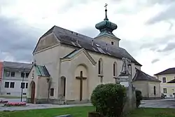 Oberweiden parish church | |
 Coat of arms | |
 Weiden an der March Location within Austria | |
| Coordinates: 48°18′N 16°49′E / 48.300°N 16.817°E | |
| Country | Austria |
| State | Lower Austria |
| District | Gänserndorf |
| Government | |
| • Mayor | Josef Dienst |
| Area | |
| • Total | 55.78 km2 (21.54 sq mi) |
| Elevation | 162 m (531 ft) |
| Population (2018-01-01)[2] | |
| • Total | 991 |
| • Density | 18/km2 (46/sq mi) |
| Time zone | UTC+1 (CET) |
| • Summer (DST) | UTC+2 (CEST) |
| Postal code | 2295 |
| Area code | 02284 |
| Website | www.weiden-march.at |
Weiden an der March is a municipality in the district of Gänserndorf in Lower Austria, Austria.
Geography
Weiden an der March lies in the Weinviertel in Lower Austria. It lies near the river Morava (German: March), which forms the border with Slovakia. 19.63% of the municipality is forested.
On 1 January 1975 the former municipalities of Baumgarten an der March, Oberweiden and Zwerndorf were merged to form Weiden an der March.
Population
| Year | Pop. | ±% |
|---|---|---|
| 1971 | 921 | — |
| 1981 | 854 | −7.3% |
| 1991 | 822 | −3.7% |
| 2001 | 904 | +10.0% |
| 2011 | 985 | +9.0% |
Economy
There are 26 companies in Weiden, and 403 persons are employed. The employment rate in 2001 was 45.79%.
References
- ↑ "Dauersiedlungsraum der Gemeinden Politischen Bezirke und Bundesländer - Gebietsstand 1.1.2018". Statistics Austria. Retrieved 10 March 2019.
- ↑ "Einwohnerzahl 1.1.2018 nach Gemeinden mit Status, Gebietsstand 1.1.2018". Statistics Austria. Retrieved 9 March 2019.
Places adjacent to Weiden an der March | ||||||||||||||||
|---|---|---|---|---|---|---|---|---|---|---|---|---|---|---|---|---|
| ||||||||||||||||
This article is issued from Wikipedia. The text is licensed under Creative Commons - Attribution - Sharealike. Additional terms may apply for the media files.