Manakara-Atsimo
Manakara Sud | |
|---|---|
 The railroad from Fianarantsoa | |
 Manakara-Atsimo | |
| Coordinates: 22°09′0″S 48°00′0″E / 22.15000°S 48.00000°E | |
| Country | |
| Region | Fitovinany |
| Government | |
| • Prefect | Béatrice Rahantamalala |
| Elevation | 12 m (39 ft) |
| Population (2018)[2] | |
| • Total | 254,344 |
| postal code | 316 |
Manakara-Atsimo is a district of Fitovinany in Madagascar.[3][4] The main city is Manakara.
Communes
The district is further divided into 42 communes:
- Ambahatrazo
- Ambahive
- Ambalaroka
- Ambalavero
- Ambila
- Amboanjo
- Ambohitsara M
- Amborondra
- Ambotaka
- Ampasimanjeva
- Ampasimboraka
- Ampasipotsy
- Analavory
- Anorombato
- Anosiala
- Anteza
- Bekatra
- Fenomby
- Lokomby
- Mahabako
- Mahamaibe
- Manakara
- Mangatsiotra
- Marofarihy
- Mavorano
- Mitanty
- Mizilo Gara
- Nihaonana
- Onilahy
- Sahanambohitra
- Saharefo
- Sahasinaka
- Sakoana
- Sorombo
- Tataho
- Vatana
- Vinanitelo
- Vohilava
- Vohimanitra
- Vohimasina Nord
- Vohimasina Sud
- Vohimasy
Rivers

Faraony from RN 12
- the Manakara River
- the Faraony River
Infrastructure
The district is crossed by the National Road 12, as well as the Fianarantsoa-Côte Est railway.
References
- ↑ Region Fitovinany
- ↑ TROISIEME RECENSEMENT GENERAL DE LA POPULATION ET DE L’HABITATION
- ↑ REPOBLIKAN’I MADAGASIKARA:Tanindrazana – Fahafahana – Fandrosoana (PDF). MINISTERE DE L’AGRICULTURE, DE L’ELEVAGE ET DE LA PECHE. October 2007. pp. 42–44. Archived from the original (PDF) on 2018-06-12. Retrieved 2018-06-09.
- ↑ "Madagascar: Administrative Division". citypopulation. Retrieved 10 June 2018.
Wikimedia Commons has media related to Manakara.
22°09′S 48°00′E / 22.150°S 48.000°E
Capital: Manakara | ||
| Ikongo (17) - 310 | 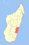 | |
| Manakara (42) - 316 |
| |
| Vohipeno (19) - 321 | ||
3 districts; 78 communes | ||
This article is issued from Wikipedia. The text is licensed under Creative Commons - Attribution - Sharealike. Additional terms may apply for the media files.