This list of caves in Missouri includes the location and date they were opened to the public (or discovered).
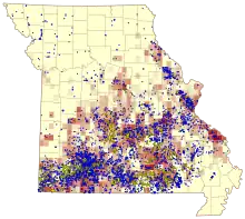
Distribution of karst features in Missouri: darker red indicates greater cave density; losing stream courses are shown in yellow; blue spots indicate known springs.
The Ozarks region has a well-developed karst topography with numerous areas of sinkholes, stream capture, and cavern development.
Caves
- Bluff Dweller's Cave (1927) - McDonald County
- Bridal Cave (1948) - Camden County
- Crevice Cave - Perry County
- Crystal Cave (1893)
- Current River Cavern (1940) - Carter County
- Devils Well (1954) - Shannon County
- Devil’s Icebox Cave - Boone County
- Fantastic Caverns (1862) - Greene County
- Friede's Cave (AKA Saltpeter Cave) (before 1865) - Phelps County
- Graham Cave (1847) – Montgomery County
- Jacobs Cavern (1903) - McDonald County
- Mark Twain Cave (1886) - Marion County
- Marvel Cave (1894) - Stone County
- Meramec Caverns (1935) - Franklin County
- Onondaga Cave (1897) - Crawford County
- Onyx Cave (1892) - Pulaski County
- Ozark Caverns (1930s) - Camden County
- Picture Cave - Warren County
- Research Cave (1950) - Callaway County
- Round Spring Cave (1932) - Shannon County
- Riverbluff Cave (2001) - Greene County
- Talking Rocks Cavern (1969) - Stone County
See also
References
This article is issued from Wikipedia. The text is licensed under Creative Commons - Attribution - Sharealike. Additional terms may apply for the media files.