Kloster | |
|---|---|
 | |
 Coat of arms | |
 Kloster Location within Austria | |
| Coordinates: 46°53′21.00″N 15°06′01.90″E / 46.8891667°N 15.1005278°E | |
| Country | Austria |
| State | Styria |
| District | Deutschlandsberg |
| Government | |
| • Mayor | Franz Farmer (SPÖ) |
| Area | |
| • Total | 22.1 km2 (8.5 sq mi) |
| Elevation | 1,050 m (3,440 ft) |
| Population (1 January 2016)[1] | |
| • Total | 194 |
| • Density | 8.8/km2 (23/sq mi) |
| Time zone | UTC+1 (CET) |
| • Summer (DST) | UTC+2 (CEST) |
| Postal code | 8530 |
| Area code | +43 3469 |
| Vehicle registration | DL |
| Website | www.kloster. steiermark.at |
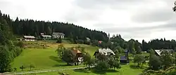
Kloster is a former municipality in the district of Deutschlandsberg in the Austrian state of Styria. Since the 2015 Styria municipal structural reform, it is part of the municipality Deutschlandsberg.[2]
Population
| Year | Pop. | ±% |
|---|---|---|
| 1848 | 284 | — |
| 1850 | 277 | −2.5% |
| 1869 | 274 | −1.1% |
| 1880 | 282 | +2.9% |
| 1890 | 273 | −3.2% |
| 1900 | 340 | +24.5% |
| 1910 | 324 | −4.7% |
| 1923 | 304 | −6.2% |
| 1934 | 310 | +2.0% |
| 1939 | 553 | +78.4% |
| 1951 | 307 | −44.5% |
| 1961 | 299 | −2.6% |
| 1971 | 300 | +0.3% |
| 1981 | 266 | −11.3% |
| 1991 | 244 | −8.3% |
| 2001 | 233 | −4.5% |
| 2011 | 202 | −13.3% |
References
This article is issued from Wikipedia. The text is licensed under Creative Commons - Attribution - Sharealike. Additional terms may apply for the media files.