Jeungpyeong
증평군 | |
|---|---|
| Korean transcription(s) | |
| • Hangul | 증평군 |
| • Hanja | 曾坪郡 |
| • Revised Romanization | Jeungpyeong-gun |
| • McCune-Reischauer | Chŭngp'yŏng-gun |
 Flag | |
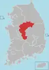
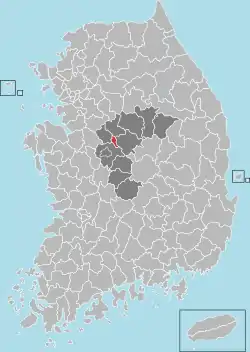 Location in South Korea | |
| Country | |
| Region | Hoseo |
| Administrative divisions | 1 eup, 1 myeon |
| Area | |
| • Total | 81.84 km2 (31.60 sq mi) |
| Population (2008) | |
| • Total | 31,276 |
| • Density | 382/km2 (990/sq mi) |
| • Dialect | Chungcheong |
| Website | jp.go.kr |
Jeungpyeong County (Jeungpyeong-gun) is a county in North Chungcheong Province, South Korea.
Location
Jeungpyeong is in the centrally located in Chungcheongbuk-do. It is located East of Jincheon, West of Goesan, south of Eumseong, north of Cheongwon.
Symbols
- county tree: Ginkgo tree
- county bird: Snowy Egret
- county flower: White Magnolia
History
- 1990, 12, 31 : Chungcheongbuk-do Jeungpyeong local office is construct of Goesan-gun jeungpyeong eup, doan myeon.
- 2003, 8, 30 : Jeungpyeong local office is raised to Jeungpyeong-gun, and it became independence from Goesan-gun.
Education
- Jeungpyeong is the site of several school and tertiary institutions, including:
Elementary school
- Doan Elementary School
- Jeungpyeong Elementary School
- Jukri Elementary School
- Sambo Elementary School
Middle school
- Fluorspar Middle School
- Jeungpyeong Middle School
- Jeungpyeong Girl's Middle School
High school
- Chungbuk Business High School
- Hyeongseok High School
- Jeungpyeong Technical High School
Tertiary Institution
Climate
Jeungpyeong has a monsoon-influenced humid continental climate (Köppen: Dwa) with cold, dry winters and hot, rainy summers.
| Climate data for Jeungpyeong (1993–2020 normals) | |||||||||||||
|---|---|---|---|---|---|---|---|---|---|---|---|---|---|
| Month | Jan | Feb | Mar | Apr | May | Jun | Jul | Aug | Sep | Oct | Nov | Dec | Year |
| Mean daily maximum °C (°F) | 2.7 (36.9) |
6.0 (42.8) |
12.4 (54.3) |
19.4 (66.9) |
25.0 (77.0) |
28.5 (83.3) |
30.0 (86.0) |
30.9 (87.6) |
26.6 (79.9) |
20.6 (69.1) |
12.6 (54.7) |
4.6 (40.3) |
18.3 (64.9) |
| Daily mean °C (°F) | −3.1 (26.4) |
−0.5 (31.1) |
5.1 (41.2) |
11.7 (53.1) |
17.5 (63.5) |
22.2 (72.0) |
25.1 (77.2) |
25.4 (77.7) |
20.1 (68.2) |
13.0 (55.4) |
5.9 (42.6) |
−1.2 (29.8) |
11.8 (53.2) |
| Mean daily minimum °C (°F) | −8.4 (16.9) |
−6.1 (21.0) |
−1.3 (29.7) |
4.7 (40.5) |
10.8 (51.4) |
16.7 (62.1) |
21.3 (70.3) |
21.5 (70.7) |
15.4 (59.7) |
7.1 (44.8) |
0.3 (32.5) |
−6.3 (20.7) |
6.3 (43.3) |
| Average precipitation mm (inches) | 18.9 (0.74) |
27.2 (1.07) |
38.9 (1.53) |
73.4 (2.89) |
75.1 (2.96) |
131.2 (5.17) |
280.1 (11.03) |
263.2 (10.36) |
124.0 (4.88) |
57.4 (2.26) |
43.1 (1.70) |
20.7 (0.81) |
1,153.2 (45.40) |
| Average precipitation days (≥ 0.1 mm) | 5.0 | 4.6 | 6.5 | 7.5 | 7.5 | 7.9 | 13.9 | 12.4 | 8.0 | 5.3 | 6.8 | 5.4 | 90.8 |
| Source: Korea Meteorological Administration[1] | |||||||||||||
Twin towns – sister cities
Jeungpyeong is twinned with:
 Guannan County, Jiangsu, China
References
- ↑ "Climatological Normals of Korea (1991 ~ 2020)" (PDF) (in Korean). Korea Meteorological Administration. Archived from the original (PDF) on 29 January 2022. Retrieved 7 June 2023.
External links
36°47′N 127°35′E / 36.783°N 127.583°E
This article is issued from Wikipedia. The text is licensed under Creative Commons - Attribution - Sharealike. Additional terms may apply for the media files.