Villa Hidalgo
Hidalgo | |
|---|---|
 Coat of arms | |
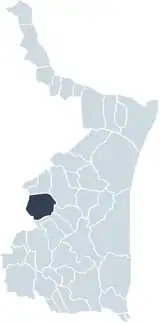 Municipality of Villa Hidalgo | |
| Coordinates: 24°14′53″N 99°26′16″W / 24.24806°N 99.43778°W | |
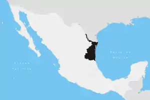
| Country | |
| State | Tamaulipas |
| Founded | May 19 1752 |
| Area | |
| • Total | 2,142.43 km2 (827.20 sq mi) |
| Elevation | 400 m (1,300 ft) |
| Population (2000) | |
| • Total | 24,281 |
| Time zone | UTC-6 (Central Standard Time) |
| • Summer (DST) | UTC-5 (Central Daylight Time) |
| Postal Code | 87800 |
| Website | http://www.vhidalgo.gob.mx |
Hidalgo Municipality (also, Villa Hidalgo) is a municipality located in the Mexican state of Tamaulipas. El Chorrito is a centre of pilgrimage in the municipality. 24°14′53″N 99°26′16″W / 24.24806°N 99.43778°W
Geography
Climate
The prevailing climate in Hidalgo is sub-humid and warm. Average rainfall is 700 millimeters, the minimum temperature is 2 °C and maximum of 41 °C.
References
External links
- Gobierno Municipal de Hidalgo Official website
This article is issued from Wikipedia. The text is licensed under Creative Commons - Attribution - Sharealike. Additional terms may apply for the media files.