Évrecy | |
|---|---|
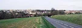 A general view of Évrecy | |
.svg.png.webp) Coat of arms | |
Location of Évrecy | |
 Évrecy 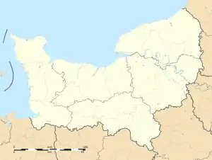 Évrecy | |
| Coordinates: 49°06′02″N 0°30′07″W / 49.1006°N 0.5019°W | |
| Country | France |
| Region | Normandy |
| Department | Calvados |
| Arrondissement | Caen |
| Canton | Évrecy |
| Government | |
| • Mayor (2020–2026) | Henri Girard[1] |
| Area 1 | 8.31 km2 (3.21 sq mi) |
| Population | 2,037 |
| • Density | 250/km2 (630/sq mi) |
| Time zone | UTC+01:00 (CET) |
| • Summer (DST) | UTC+02:00 (CEST) |
| INSEE/Postal code | 14257 /14210 |
| Elevation | 58–122 m (190–400 ft) (avg. 110 m or 360 ft) |
| 1 French Land Register data, which excludes lakes, ponds, glaciers > 1 km2 (0.386 sq mi or 247 acres) and river estuaries. | |
Évrecy (French pronunciation: [evʁəsi] ⓘ) is a commune in the Calvados department in the Normandy region in northwestern France situated on the River Guigne.
Population
| Year | Pop. | ±% p.a. |
|---|---|---|
| 1968 | 619 | — |
| 1975 | 828 | +4.24% |
| 1982 | 1,099 | +4.13% |
| 1990 | 1,093 | −0.07% |
| 1999 | 1,263 | +1.62% |
| 2007 | 1,525 | +2.38% |
| 2012 | 1,824 | +3.65% |
| 2017 | 2,008 | +1.94% |
| Source: INSEE[3] | ||
See also
References
- ↑ "Répertoire national des élus: les maires" (in French). data.gouv.fr, Plateforme ouverte des données publiques françaises. 13 September 2022.
- ↑ "Populations légales 2021". The National Institute of Statistics and Economic Studies. 28 December 2023.
- ↑ Population en historique depuis 1968, INSEE
Wikimedia Commons has media related to Évrecy.
This article is issued from Wikipedia. The text is licensed under Creative Commons - Attribution - Sharealike. Additional terms may apply for the media files.