| Earl's Seat | |
|---|---|
 Earl's Seat | |
| Highest point | |
| Elevation | 578 m (1,896 ft)[1] |
| Prominence | 511 m (1,677 ft) |
| Isolation | 19.89 km (12.36 mi) |
| Listing | Marilyn |
| Coordinates | 56°01′33″N 4°17′47″W / 56.0257°N 4.2964°W |
| Geography | |
| Location | East Dunbartonshire / Stirling, Scotland |
| Parent range | Campsie Fells |
| OS grid | NS570838 |
| Topo map | OS Landranger 57, 64 |
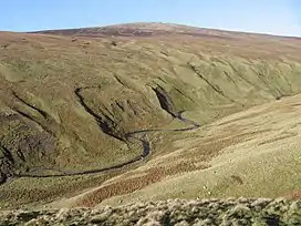
Earl's Seat (578 m) is the highest hill of the Campsie Fells in Central Scotland. It lies on the border of Stirlingshire and East Dunbartonshire in central Scotland. Located on a plateau in the heart of the Campsies above the village of Strathblane, its summit is marked by a trig point.[2]
References
- ↑ "Earl's Seat". hill-bagging.co.uk. Retrieved 1 November 2019.
- ↑ "Earl's Seat". walkinghighlands.co.uk. Retrieved 1 November 2019.
This article is issued from Wikipedia. The text is licensed under Creative Commons - Attribution - Sharealike. Additional terms may apply for the media files.