Dange Shuni | |
|---|---|
LGA and town | |
 Dange Shuni | |
| Coordinates: 12°51′N 5°21′E / 12.850°N 5.350°E | |
| Country | |
| State | Sokoto State |
| Area | |
| • Total | 1,210 km2 (470 sq mi) |
| Population (2006) | |
| • Total | 194,546 |
| Time zone | UTC+1 (WAT) |
| 3-digit postal code prefix | 852 |
| ISO 3166 code | NG.SO.DS |
Dange Shuni is a Local Government Area in Sokoto State, Nigeria. Its headquarters are in the town of Dange.
It has an area of 1,210 km2 and a population of 194,546 at the 2006 census.[1]
The postal code of the area is 852.[2]
Climate
The climate varies throughout the year between a wet season that is primarily cloudy and a dry season that is mostly hot and partly cloudy.[3][4]
Temperature
In Danger, the months with the highest average daily highs exceeding 100°F are April and January, respectively. April is the hottest month.[3]
References
- ↑ HASC, population, area and Headquarters Statoids
- ↑ "Post Offices- with map of LGA". NIPOST. Archived from the original on 2009-10-07. Retrieved 2009-10-20.
- 1 2 "Dange Climate, Weather By Month, Average Temperature (Nigeria) - Weather Spark". weatherspark.com. Retrieved 2023-08-31.
- ↑ "Dange Shuni, Sokoto, Nigeria - City, Town and Village of the world". en.db-city.com. Retrieved 2023-08-31.
State capital: Sokoto | ||
| Local Government Areas | 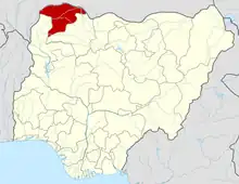 | |
This article is issued from Wikipedia. The text is licensed under Creative Commons - Attribution - Sharealike. Additional terms may apply for the media files.