Cana | |
|---|---|
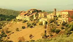 View of Cana | |
 Cana Location of Cana in Italy | |
| Coordinates: 42°47′47″N 11°25′32″E / 42.79639°N 11.42556°E | |
| Country | |
| Region | |
| Province | Grosseto (GR) |
| Comune | Roccalbegna |
| Elevation | 480 m (1,570 ft) |
| Population (2011) | |
| • Total | 263 |
| Demonym | Canesi |
| Time zone | UTC+1 (CET) |
| • Summer (DST) | UTC+2 (CEST) |
| Postal code | 58053 |
| Dialing code | (+39) 0564 |
Cana is a village in Tuscany, central Italy, administratively a frazione of the comune of Roccalbegna, province of Grosseto, in the southern area of Mount Amiata. At the time of the 2001 census its population amounted to 225.[1]
Cana is about 32 km from Grosseto and 11 km from Roccalbegna.
Main sights
- San Martino (13th century), main parish of the village, it was rebuilt in 1970.
- Madonna del Conforto (15th century), little chapel which contains the painting of Vergine del Conforto.
- Walls of Cana, old fortifications which surround the village since 13th century.
- Rocca aldobrandesca (13th century), a fortress built by Aldobrandeschi family.
- Medicean well, a 17th-century well built by Medici.
References
- ↑ (in Italian) Popolazione residente - Grosseto (dettaglio loc. abitate) - Censimento 2001 Archived 2018-08-26 at the Wayback Machine, Istat
See also
Wikimedia Commons has media related to Cana (Roccalbegna).
This article is issued from Wikipedia. The text is licensed under Creative Commons - Attribution - Sharealike. Additional terms may apply for the media files.