Hoppegarten | |
|---|---|
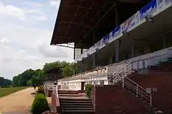 The Hippodrome | |
 Coat of arms | |
Location of Hoppegarten within Märkisch-Oderland district 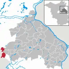 | |
 Hoppegarten  Hoppegarten | |
| Coordinates: 52°31′00″N 13°40′00″E / 52.51667°N 13.66667°E | |
| Country | Germany |
| State | Brandenburg |
| District | Märkisch-Oderland |
| Subdivisions | 3 Ortsteile |
| Government | |
| • Mayor (2019–27) | Sven Siebert[1] |
| Area | |
| • Total | 31.88 km2 (12.31 sq mi) |
| Elevation | 50 m (160 ft) |
| Population (2021-12-31)[2] | |
| • Total | 18,322 |
| • Density | 570/km2 (1,500/sq mi) |
| Time zone | UTC+01:00 (CET) |
| • Summer (DST) | UTC+02:00 (CEST) |
| Postal codes | 15366 |
| Dialling codes | 03342, 030 |
| Vehicle registration | MOL |
| Website | gemeinde-hoppegarten |
Hoppegarten is a municipality in the district Märkisch-Oderland, in Brandenburg, Germany.
History
The current municipality was created in 2003 when the former municipalities of Hönow and Münchehofe were united with Dahlwitz-Hoppegarten. The old Dahlwitz-Hoppegarten is now a district composed by Birkenstein and Waldesruh.
Geography

Hoppegarten is located close to the eastern suburbs of Berlin (Mahlsdorf, in the borough of Marzahn-Hellersdorf). The other bordering municipalities are Ahrensfelde (BAR), Werneuchen (BAR), Altlandsberg, Neuenhagen and Schöneiche (LOS).
The municipality is composed by three urban districts (Ortsteil): Dahlwitz-Hoppegarten, Hönow (detached from the rest of municipal area by a strip belonging to Berlin) and Münchehofe.
Transport
The town is served by Berlin S-Bahn and it has 2 stations on S5 line (Birkenstein and Hoppegarten). The Berlin U-Bahn line U5 has its end station in Hönow.
Demography
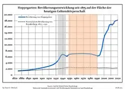 Development of Population since 1875 within the Current Boundaries (Blue Line: Population; Dotted Line: Comparison to Population Development of Brandenburg state; Grey Background: Time of Nazi rule; Red Background: Time of Communist rule)
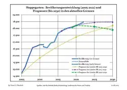 Recent Population Development and Projections (Population Development before Census 2011 (blue line); Recent Population Development according to the Census in Germany in 2011 (blue bordered line); Official projections for 2005-2030 (yellow line); for 2017-2030 (scarlet line); for 2020-2030 (green line)
|
|
|
Twin towns
See also
References
- ↑ Landkreis Märkisch-Oderland Wahl der Bürgermeisterin / des Bürgermeisters, accessed 1 July 2021.
- ↑ "Bevölkerungsentwicklung und Flächen der kreisfreien Städte, Landkreise und Gemeinden im Land Brandenburg 2021" (PDF). Amt für Statistik Berlin-Brandenburg (in German). June 2022.
- ↑ Detailed data sources are to be found in the Wikimedia Commons.Population Projection Brandenburg at Wikimedia Commons
External links
![]() Media related to Hoppegarten at Wikimedia Commons
Media related to Hoppegarten at Wikimedia Commons
- (in German) Official site of Hoppegarten