Blankenheim | |
|---|---|
 | |
_COA.svg.png.webp) Coat of arms | |
Location of Blankenheim within Euskirchen district | |
 Blankenheim 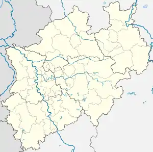 Blankenheim | |
| Coordinates: 50°26′N 06°39′E / 50.433°N 6.650°E | |
| Country | Germany |
| State | North Rhine-Westphalia |
| Admin. region | Cologne |
| District | Euskirchen |
| Founded | 721 |
| Subdivisions | 17 |
| Government | |
| • Mayor (2020–25) | Jennifer Meuren[1] |
| Area | |
| • Total | 148.62 km2 (57.38 sq mi) |
| Elevation | 455 m (1,493 ft) |
| Population (2021-12-31)[2] | |
| • Total | 8,337 |
| • Density | 56/km2 (150/sq mi) |
| Time zone | UTC+01:00 (CET) |
| • Summer (DST) | UTC+02:00 (CEST) |
| Postal codes | 53945 |
| Dialling codes | 02449 & 02697 |
| Vehicle registration | EU |
| Website | www.blankenheim-ahr.de |
Blankenheim is a municipality in the district of Euskirchen in the state of North Rhine-Westphalia, Germany.
Geography
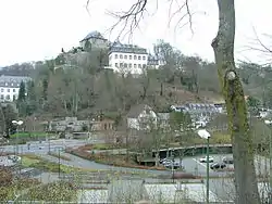
Parish church St. Mariä Himmelfahrt and Blankenheim Castle
Source of the Ahr in Blankenheim
Blankenheim is located in the Eifel hills, approximately 27 km (17 mi) south-west of Euskirchen. The river Ahr has its source in the centre of Blankenheim, in the cellar of a half timbered house.
History
In the year 721, Blankenheim is mentioned for the first time as "Blancio" in a document. Today, the municipality is called in Eifel dialect as "Blangem" and has got a long carnival tradition.
See also
References
- ↑ Wahlergebnisse in NRW Kommunalwahlen 2020, Land Nordrhein-Westfalen, accessed 19 June 2021.
- ↑ "Bevölkerung der Gemeinden Nordrhein-Westfalens am 31. Dezember 2021" (in German). Landesbetrieb Information und Technik NRW. Retrieved 20 June 2022.
External links
Wikimedia Commons has media related to Blankenheim (Ahr).
- Official website (in German)
- Tourist info
- Eifel Museum Blankenheim (in German)
Towns and municipalities in Euskirchen (district) | ||
|---|---|---|
Coat of Arms of Euskirchen County | ||
This article is issued from Wikipedia. The text is licensed under Creative Commons - Attribution - Sharealike. Additional terms may apply for the media files.